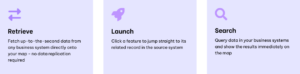
Connect for ArcGIS revolutionises data integration within ArcGIS. Now you can seamlessly access real-time data from third-party systems directly within your existing mapping applications.
Connect for ArcGIS ships with pre-built, point-and-click connectors that let you build
integration workflows from ArcGIS Experience Builder to your critical business systems
in minutes – no code, no context-switching.
Built into ArcGIS Experience Builder, Connect feels like part of
your existing workflow – because it is.
The user-friendly admin console makes it easy to create smart connections
between your maps and enterprise systems
Connect for ArcGIS comes with a library of ready-to- use connectors for real-time integration
with enterprise platforms—no coding required.
Need something custom? We can build that too
Out-of-the-box support includes: Salesforce, ServiceNow, Microsoft
(including SharePoint and Dynamics), relational databases such as SQL Server and
Postgres, and many more
| Installation | Features: Radar overlay: Pulls recent and forecasted radar imagery and displays on the map. |
|---|